Photograph by Ryan Hayslip
One of our top sources for interpreting the vast Georgia wilds was Jonah McDonald, adventure leader and author of the book Hiking Atlanta’s Hidden Forests: Intown and Out. We came up with this shorthand field guide, with our top picks broken down into three levels of difficulty. Plus, finding trailheads can be tricky, so we navigated them for you.
Level of difficulty key
● Easy (and close by!) 3 miles or less, minimal elevation change, and within 20 miles of Downtown
■ Moderate 4 to 10 miles, less than 800 feet elevation gain
▲ Strenuous More than 1,000 feet of elevation gain
Amicalola Falls State Park
Hike Inn Trail
Level of difficulty ■ Moderate
Mileage 10 miles round-trip
Elevation gain Less than 800 feet
➽Why go This hike has long been a favorite of Backpacker magazine, and we understand why. The Chattahoochee National Forest is at its best here, offering a rich cast of flora for all seasons and consistent terrain. But the cherry on top is the rustic inn itself (see page 79), where you can stay the night in a bunk room and have two meals for a bargain price—or stop and rest, have a snack, and turn right back around. Ten miles in a day on this trail is very doable.
➽Don’t miss Just below the trailhead is Amicalola Falls, a 729-foot waterfall that’s the tallest in Georgia and one of the state’s “seven natural wonders.” On the trail itself, look out for enormous trees: hickory, pine, oak, and more. There’s a yellow poplar about a mile in that takes at least two people to lock arms around. In spring and summer, you’ll be tempted to pick wildflowers like dwarf iris and trillium. After a good rain in July and August, you’re likely to see chanterelle mushrooms popping up.
➽Best for Avid intown walkers looking for a moderate hike within ninety minutes of Atlanta that will convince them the woods are even better than the neighborhood park.
➽How to get there The trail begins at the Hike Inn parking area at the top of Amicalola Falls. If you’re staying at the inn, you need to check in at the Amicalola Falls State Park visitors center, just inside the park entrance, by 2 p.m. Reservations encouraged. $5 daily parking fee; annual passes providing access to all state parks are $50. Top of the Falls Road, Dawsonville; gastateparks.org/amicalolafalls, hike-inn.com

Davidson-Arabia Nature Preserve
Mountain View Trail (plus Mountain Top Trail)
Level of difficulty ● Easy (and close by!)
Mileage 2.5-mile loop (+ .5 mile out and back)
Elevation gain Minimal (+ 180 feet)
➽Why go Many have climbed to the top of this monadnock (a rock outcrop, like its younger brother, Stone Mountain) east of Atlanta, but the Mountain View trail is just two years old and little known. The gently rolling path starts across a stretch of unadorned granite that feels otherworldly (one in our party asked, “Why haven’t they filmed The Walking Dead here yet?”). Then it tucks in and out of a forest along a small lake and plops you back out at the junction with the Mountain Top trail. From there, follow the cairns .2 miles up the granite field to the summit, where there’s nothing but treetops in sight.
➽Wildflowers Take care to step around the small pools stippling the granite. The “solution pits,” as they are unromantically called, are the primary habitat for a rare plant called diamorpha, which appears as low-slung, bright red succulents in winter; spectacular white flowers in late spring; and dry brown stems in the summer. Also spot mountain laurel, rare to metro Atlanta.
➽Good to know Leashed dogs are welcome at Arabia, but we wouldn’t bring a pup out there on a hot day: The sun-baked granite looks like it’d be hard on the paw pads. Also, watch for the blue blazes marking the way; they’re easy to miss at times.
➽How to get there For this trail, park by the AWARE (Atlanta Wild Animal Rescue Effort) at 4158 Klondike Road (not by the nature center at 3787 Klondike Road). arabiaalliance.org
Photograph by Ryan Hayslip
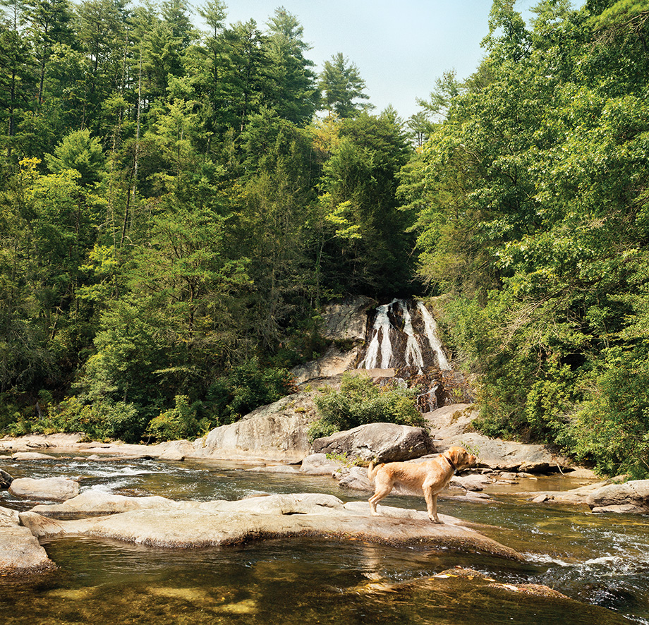
Bartram Trail
from Sandy Ford to Warwoman Dell
Level of difficulty ■ Moderate
Mileage 9.3 miles round-trip
Elevation gain Less than 500 feet
➽Why go The Bartram Trail may offer some of the prettiest terrain in North Georgia, judging by this section along the Chattooga River. If you like scenic camping, particularly near smooth-running water, this is your Shangri-la. Bugs aren’t bad. Campsites are large but clean. A variety of deciduous and evergreen trees offer a cooling canopy. And it’s both easy to reach by foot (the first sites appear within a mile along the yellow-blazed trail) and remote enough by car (expect to traverse a few dirt roads) that you may find yourself alone.
➽Don’t miss Less than a quarter mile into this hike, you’ll come across a side trail (marked with green diamonds) to Dick’s Creek Falls. Take it. You’ll meander a few tenths of a mile downhill to the Chattooga River, where you can look up at the four-tongued descent of the falls. There are a number of places to wade, dip, and slide. Watch for fish swimming around your ankles, including the Bartram’s Bass.
➽Famous for The full trail, more than 100 miles, is named for the eighteenth-century botanist-artist-writer William Bartram, whose book Travels chronicled his adventures in the pristine natural landscapes of the pre–Civil War American South. Later, the Chattooga River provided a more sullied setting for the 1972 filming of Deliverance.
➽How to get there From Clayton, take Warwoman Road 5.9 miles east from U.S. 441, then turn right on Sandy Ford Road. A little over half a mile in, turn left onto a concrete bridge over Warwoman Creek; 3.3 miles later, reach a “splash-through” creek crossing over Dicks Creek. A few hundred yards later, the trail begins on the left side of Sandy Ford Road. You can do this as an out-and-back or by shuttling two cars from from point A to point B.
Photograph by Ryan Hayslip
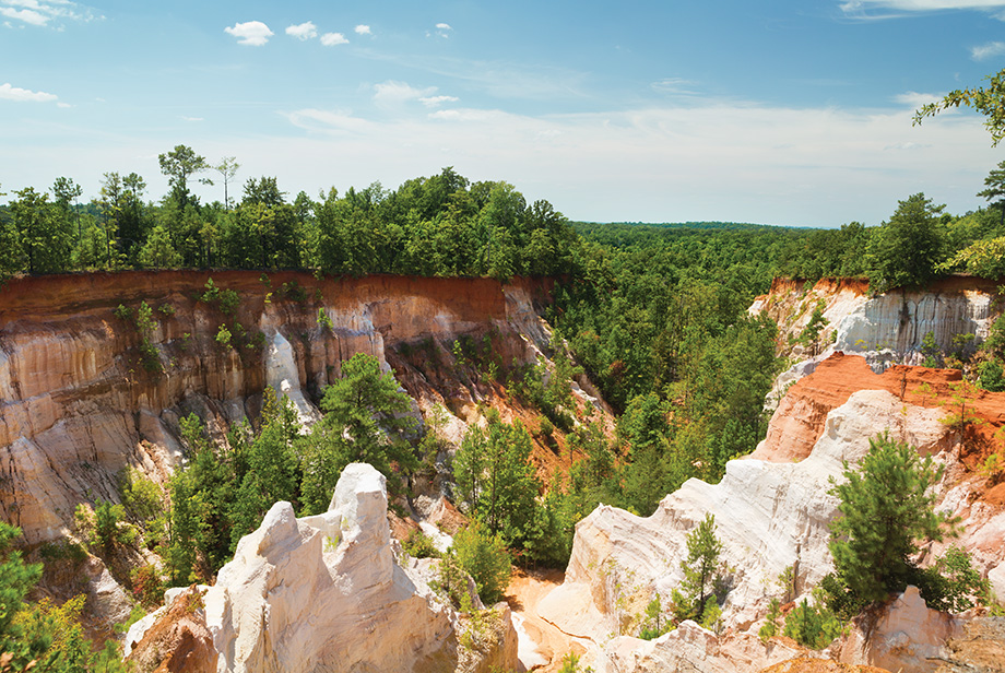
Providence Canyon state park
Backcountry Trail
Level of difficulty ■ Moderate
Mileage 7-mile loop
Elevation gain Less than 500 feet
➽Why go This geographic anomaly, forty miles south of Columbus, is another of the state’s seven natural wonders, and there’s nothing like it east of the Mississippi. But Georgia’s Little Grand Canyon isn’t natural at all, formed initially by erosion from poor nineteenth-century farming practices and now cutting as deep as 150 feet in the loamy Georgia soil. The backcountry loop offers six campsites with fire pits and smooth ground for tenting. You’ll find some of the starriest skies in the state down here, and mild temps in winter.
➽Don’t miss There are sixteen canyons in the state park, but we especially liked the first five, where the three ancient soil layers—Clayton (red), Providence (white), and Ripley (often orange)—are most dramatically on display from above. Look for the rare red and orange wild plumleaf azalea along the canyon floor.
➽Best for Everyone who thinks that South Georgia is nothing but the Statesboro Blues. Also, if you’ve always wanted to see the great canyons out West but haven’t had the time or resources, this is the cheap and easy way to enjoy a smaller rendering.
➽How to get there The trail begins just beyond the state park’s visitors center, less than a tenth of a mile from the main lot. $5 daily parking fee; annual passes providing access to all state parks are $50; $10 for a backcountry campsite. 8930 Canyon Road, Lumpkin; gastateparks.org/providencecanyon
Cloudland Canyon State Park
West Rim Loop Trail (Plus waterfalls Trail)
Level of difficulty ■ Moderate
Mileage 4.8-mile loop (+ 1 mile out and back)
Elevation gain 300 feet (+ 300 feet)
➽Why go The West Rim Loop, so named because it follows the rim of the deep gorge on the western edge of Lookout Mountain, provides vista after rewarding vista. We recommend adding the short trail into the gulch to Cherokee Falls, down and up 223 steps (we counted!), to see the sixty-foot falls cascading over sandstone and shale into a blue pool decorated with mossy rocks. If that’s not enough, you can add close to a mile to see the ninety-foot Hemlock Falls.
➽Don’t miss Many go to Cloudland just for the falls, where large families brave the heart-attack warning (it’s chiseled into a very official-looking wooden sign) and gingerly tackle the metal-grate stairs. The falls are worth a visit, but the view from atop the steep west-rim escarpment is a prime place for fall leaf-peeping.
➽FYI Don’t bother with your bathing suit: Swimming beneath the falls is strictly prohibited, despite being extremely enticing. Do consider getting lunch or a beer afterward in Chattanooga, about twenty miles away via the scenic route on GA-189, or reserve one of the yurts along the trail for the night.
➽How to get there The West Rim Loop trail starts adjacent to the picnic shelters and visitors center and small museum. $5 daily parking fee; annual passes providing access to all state parks are $50. 122 Cloudland Canyon Park Road, Rising Fawn; gastateparks.org/cloudlandcanyon
Sweetwater Creek State Park
Yellow Trail
Level of difficulty ● Easy (and close by!)
Mileage 3-mile loop
Elevation gain 350 feet
➽Why go Most Atlantans know Sweetwater Creek State Park, but fewer know its yellow trail, which takes you to the east side of the eponymous waterway and away from the morning dog walkers and sightseers who’ve come for the west bank ruins of the New Manchester Mill. Sandy bottomland hardens to clay and stone as you ascend the ridge covered by the thick canopy of oak and pine. Head back down to the broad creek that rushes over the natural rock dam; the rapids and ruins can be spotted downstream.
➽Don’t miss History buffs who’ve come for the mill, which was burned in the Civil War, will want to catch a much older shelter: a shallow cave worn into the bluff halfway up the hill, where ancient fire pits and smoke stains remain from use by Native Americans.
➽Terrain The river bottom trail is flat and winding but well marked with yellow paint. When you get to the hill fork, go left, taking the circuit clockwise for a more gradual ascent lined with plenty of benches for breathers.
➽How to get there Do not rely on GPS. Coming from I-20, pass the Bait Shack (in map below) on your left, then less than a quarter mile south, make a left onto Factory Shoals Road and follow the signs to the interpretive center and nature trails. $5 daily parking fee; annual passes providing access to all state parks are $50. 1750 Mt. Vernon Road, Lithia Springs; gastateparks.org/sweetwatercreek
Morningside Nature Preserve
Level of difficulty ● Easy (and close by!)
Mileage 2-mile loop
Elevation gain Less than 250 feet
➽Why go The preserve is an ideal respite for intowners, with only an occasional train whistle or faint whoosh of traffic as a reminder that you’re in the middle of the city. This thirty-acre urban forest was saved from development by Morningside neighbors in the late nineties and is now part of the City of Atlanta parks system. Starting at the Lenox Road parking lot, the trail winds through towering walls of kudzu and dense stands of mature hardwoods. The most strenuous part is climbing a hillside staircase on the way back to the lot.
➽Don’t miss About half a mile in is a wooden suspension bridge over the South Fork of Peachtree Creek. Before you cross, veer right for a path leading down to a sandy beach that’s particularly popular among dog owners.
➽Something extra Head south from the parking lot and stroll past the well-manicured homes on Lenox Road on your way to brunch at Rosebud or Alon’s Bakery & Market (1.3 miles away) on North Highland Avenue. On your return, detour west to the tiny Morningside Nature Trail in Sussex Park.
➽How to get there Park in the designated lot on Lenox Road. 2020 Lenox Road.

Photograph by Ryan Hayslip
Constitution Lakes Park
Level of difficulty ● Easy (and close by!)
Mileage 2.25 miles round-trip
Elevation gain Minimal
➽Why go Unexpected curiosities await on this urban hike, which recently added a trail to make a loop. A green patch tucked amid industrial warehouses in south DeKalb, it was once a brick manufacturing site; the excavation pits for clay have filled and made for healthy wetlands, with turtles, herons, and kingfishers all a common sight. Folk art dots a loop, the Doll’s Head Trail, at the far end of the path.
➽Urban art The Doll’s Head Trail was created by zealous volunteers who pick up trash (old TVs, barrels, dolls) washed up in the floods of the nearby South River and turn it into trail art in the spirit of Thornton Dial and Howard Finster. It’s creepy, thought-provoking, and funny, and you’re encouraged to add to the madness, as long as you use only objects found on-site.
➽FYI The first half mile is paved and leads to an accessible boardwalk vista. Fishing is legal in DeKalb County parks, and you’ll see locals casting a line every evening at dusk. Sometimes the boardwalk gets a bit littered.
➽How to get there South River Industrial Boulevard dead ends into the trail’s parking lot after it crosses Moreland Avenue. South River Industrial Boulevard.
Vogel State Park
Coosa Backcountry Trail
Level of difficulty ▲ Strenuous
Mileage 12.5-mile loop
Elevation gain More than 4,000 feet
➽Why go This is true valley-to-ridge walking—an old-school Appalachian experience. As such, it’s a tough trail; you won’t be following watersheds here. The Chattahoochee National Forest and Blood Mountain Wilderness are on full display as you head straight up two of the tallest mountains in the state: Slaughter Mountain and Coosa Bald (which is no longer bald). As you cross land where the Cherokee and Creek tribes once battled (hence the chilling names), you’ll encounter rhododendron-filled hollows and epic fall and winter views into Vogel State Park below.
➽Which way We suggest hiking in a counterclockwise direction; otherwise the ups and downs of the trail’s first few miles will be especially killer—unless, of course, that’s what you’re after.
➽Best for Experienced trail runners looking for a pretty, relatively people-free trail to train hard. It’s also a top-notch option for a two-day backcountry camping trip. There are a number of nice campsites about six miles in with flat ground and, occasionally, even stacked wood for a fire. If you choose the two-day option (recommended), it’s more moderate than strenuous.
➽How to get there The trail begins at a parking lot beside Lake Trahlyta in Vogel State Park. You’ll need a permit for backcountry camping. $5 daily parking fee; annual passes providing access to all state parks are $50. 405 Vogel State Park Road, Blairsville; gastateparks.org/vogel
F.D. Roosevelt State Park
Pine Mountain Trail (Dowdell’s Knob Loop)
Level of difficulty ■ Moderate
Mileage 4.3-mile loop
Elevation gain 665 feet
➽Why go If you’re looking for a change of direction, you can actually head south of Atlanta for a serious hike on the twenty-three-mile Pine Mountain Trail system that threads the length of F.D. Roosevelt State Park. The descent from the mountain summit is steep, on a wending rock path occasionally speed-bumped with trees felled by a 2011 tornado. The valley is cool and canopied, with a small waterfall signaling the ascent by way of a narrow, sun-drenched ledge.
➽History The natural wonder of these foothills, along with the nearby warm springs, was a salve for the polio-stricken thirty-second president. The Knob was one of FDR’s favorite spots for both entertaining guests and solitary contemplation. He was so at ease here, it was one of the only places he wore his leg braces outside his pants, as the statue of him here shows—the only one of its kind.
➽Tip The trailhead is a few hundred feet from Dowdell’s Knob, the highest point of the nearly 1,400-foot mountain, but save it for the end of the three-and-a-half-hour loop. The boundless view of the lush green valley is so much sweeter after the climb.
➽How to get there $5 daily parking fee; annual passes providing access to all state parks are $50. 2970 Georgia Highway 190, Pine Mountain. gastateparks.org/fdroosevelt
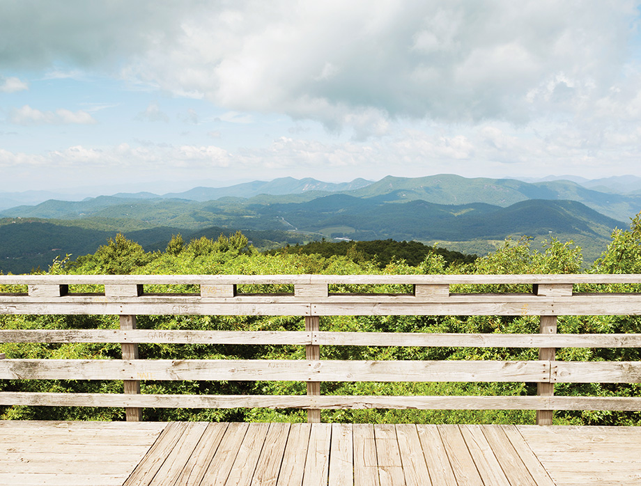
Cohutta Wilderness
Hemp Top Trail
Level of difficulty ▲ Strenuous
Mileage 12.4 miles round-trip
Elevation gain More than 2,000 feet
➽Why go Some say this is the least traveled trail in the vast, remote Cohutta Wilderness of North Georgia, which continues into Tennessee with a different name, Big Frog Wilderness. Together, they comprise more than 40,000 acres—the largest wilderness area east of the Mississippi. Give yourself a solid seven hours, at least, to soak up the solitude on this trail. Linger for lunch a little more than five miles in at Double Springs Gap, which sits at the Georgia-Tennessee line and offers a few nice campsites if you want to make it an overnighter.
➽Don’t miss The wintertime views along the ridge are stunning—particularly from the 4,224-foot peak of Big Frog Mountain in Tennessee, which marks the highest westernmost land in the eastern U.S. (if you can wrap your head around that).
➽Best for Experienced hikers who want to push themselves amid a remote swath of wilderness most wouldn’t expect to find in Georgia but is just two hours from Atlanta.
➽How to get there This trailhead doesn’t come with a clear landmark on a map. Coming from Blue Ridge, at the major intersection at Watson Gap, turn a hard right on Forest Service Road 22, then drive 3.6 miles to the trailhead at Dally Gap.
Bartram Trail
Rabun Bald
Level of difficulty ▲ Strenuous
Mileage 4 miles round-trip
Elevation gain More than 1,000 feet
➽Why go At 4,696 feet, Rabun Bald is the second-highest peak in Georgia. But unlike Brasstown Bald—the state’s highest—you can’t drive a paved road to the top. There are three different paths, but we prefer this short trail, at times steep, approaching the summit from the north. You’ll traverse switchbacks early on, winding through the giant old oaks, but with a half mile to go, the trail gets fairly rugged and climbs straight up.
➽Don’t miss The observation deck atop the mountain—built by the Civilian Conservation Corps in the 1930s—provides sweeping, 360-degree views of the Blue Ridge Mountains in North Carolina, South Carolina, and Georgia. On a clear day, you might even see Atlanta’s skyline. If you’re lucky, you could catch a glimpse of a rare peregrine falcon.
➽Foraging Bring a little basket to collect the blackberries and blueberries you’ll likely find along the trail in spring and summer. Black bears like them too, however. Seeing a bear is unlikely (see sidebar on page 72), but toss some bear spray in your basket if you’re worried.
➽How to get there From the junction of Hale Ridge Road (Forest Service Road 7) and Warwoman Road, travel about 5.5 miles north on Hale Ridge Road. There, the trail begins on the left at about 3,280-feet.
Photograph by Ryan Hayslip