
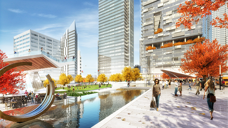
Rendering by Jacobs; Photo illustration by Gluekit
Atlanta has had its share of game-changing development projects over the past couple of decades. Centennial Olympic Park. Atlantic Station. The Atlanta BeltLine.
Now an alliance of neighborhood boosters and downtown landowners is pushing an ambitious new proposal, bearing an estimated price tag of $300 million. They believe it can bring about a fresh renaissance in Atlanta’s urban core and finally erase the half-century-old barrier between downtown and Midtown.

Meet “the Stitch”: a plan—concept, really—to cap the Downtown Connector by building concrete decking over the top of I-75/85 from the Spring Street flyover southeast to the Piedmont Avenue bridge. The effort would turn a half-mile stretch of interstate highway into a tunnel. More importantly, it would create 14 acres of new terrain out of what is now a no-man’s land of surface parking, empty lots, and an open trench containing a dozen lanes of traffic—metaphorically restitching the urban fabric that was torn by the placement of the freeway.
That new landscape could include public greenspace to host concerts and events—parks bracketed by newly reconnected streets that now dead-end. It would also—perhaps by financial necessity—include a cluster of new hotels, residential buildings, and office towers, according to a study that forms the conceptual blueprint for the Stitch.
“We’re trying to create an urban amenity that will spur development,” says A.J. Robinson, president of Central Atlanta Progress, the nonprofit devoted to promoting economic development downtown. It spent close to $100,000 to commission the 114-page study from the Atlanta office of Jacobs, a global engineering company based in Pasadena.
In CAP’s vision, the Stitch would serve as a blank slate for private development on top of the highway. The state, which owns I-75/85, could recoup a chunk of the cost of capping the highway by selling air rights to developers, the study explains. The finished project, it predicts, would bring about a surge in surrounding property values and set off a chain reaction of building and redevelopment of existing properties, like the long-vacant Medical Arts Building, which now overlooks the interstate.
It’s that public-private partnership aspect of the Stitch that makes its realization appear more likely—Robinson says a first phase could be completed within five years—than a project that depends solely on government funds. So far, he says, the surrounding property owners—Cousins Properties, Emory Hospital, Georgia Power, Portman Holdings, and St. Luke’s Episcopal Church—are enthusiastic supporters of the plan. His group has also given well-received presentations to City Hall; the Federal Highway Administration; Midtown Alliance, CAP’s counterpart to the north; MARTA; and the state Department of Transportation, which would be a partner in the project, says Jennifer Ball, CAP’s vice president of planning and economic development. John McColl, executive vice president at Cousins, one of Atlanta’s top commercial developers, says his company is eager to offer support and leadership to help see the project through.

Next, CAP will approach its corporate members to raise the $1 million needed to conduct preliminary engineering work, which will determine how the Stitch should be built and, crucially, how much it would cost. The early estimate of $300 million is based on the per-acre cost of a similar project in Dallas, Klyde Warren Park.
As envisioned by CAP, the Stitch would not be a single open space like that in Dallas, but a series of five or six parks and plazas. The new greenspaces could have fountains and other water features, retail and food pavilions, sculptures and large-scale public artwork, and statues and monuments dedicated to civic leaders. The rest of the area would be consumed by new streets and private development.
An advantage the Atlanta project has over the Dallas park is the presence of rapid transit. With doors that open uninvitingly onto the West Peachtree Street overpass, MARTA’s Civic Center Station has long been one of the system’s least-used stations. But with newly created land around it, it would likely spur the development of rental housing.
Although the name is new, the idea behind the Stitch has been around for years, appearing in previous planning documents and maps published by CAP. But the striking success of Klyde Warren Park has helped spur interest in highway-capping projects in cities around the country. In May, the Atlanta Regional Commission took a delegation of elected officials and community leaders to Dallas as part of its annual trip to see how other cities handle growth challenges.
Last September the Buckhead Community Improvement District unveiled the concept for its own highway cap—a nine-acre park built on top of Georgia 400 stretching from Peachtree Road north to Lenox Road. That project is slated to cost between $150 million and $200 million.
Barbara Faga, former chairperson of the urban design firm EDAW, which designed Centennial Park, says a proposal like the Stitch should have little difficulty securing public and private backing. “Who could be against increasing the downtown tax base and adding new development?” she says. “Atlanta is used to taking on big projects. All you need is the right leadership and the money will follow.”
Faga also worked on Boston’s “Big Dig,” and says the obstacles facing the Stitch are much less daunting because I-75/85 is already below street level.
The Stitch also would eliminate the hard line that’s existed between downtown and Midtown since the highway was carved through Atlanta in the late 1940s. BeltLine visionary Ryan Gravel says it’s difficult to overstate the potential impact of a seamless connection between the two now-distinct parts of town.
“If the city is to accommodate future growth, you have to leverage the downtown core, but it has to be a desirable place to be. Right now it’s fragmented and difficult to navigate, especially on foot,” he says. “This is a logical place to start.”
The Stitch sitch
Here’s what’s being proposed

What is the stitch?
A proposal to cover a half mile of I-75/85 with greenspace and private development, named for its potential to reconnect downtown and Midtown.
What would it cost?
A very early estimate places construction costs at $300 million, some of which would be recouped by selling air rights.
Potential impact
A conceptual study predicts that the Stitch could spur residential and commercial development in the northern end of downtown, in addition to creating new public spaces.

Photograph courtesy of the Office of James Burnett
Similar projects in other cities
Klyde Warren Park
What is it?
The five-acre greenspace, built directly over a state highway near the heart of Dallas’s arts district, opened in 2012.
What did it cost?
Nearly half of the $110 million cost of the project came from private sources, with the balance borne by the city, state, and federal governments.
Local impact
Area rents have climbed as much as 50 percent. The park has become an epicenter of activity for tourists and locals—attracting 2 million visitors in its first two years. An apartment-building boom has ignited to capitalize on a renewed interest in downtown living.
Boston’s “Big Dig”
What is it?
Boston relocated miles of urban highway underground and famously tunneled under its harbor to add a new interstate loop.
What did it cost?
The most expensive highway project in U.S. history, the Big Dig cost $15 billion (plus interest)—more than five times the estimated price—and took 15 years to build.
Local impact
Officially completed in 2006, the mega-project left a 1.5-mile greenbelt running through the city’s urban core. It’s credited with spurring a building boom that has revitalized Boston’s downtown and caused property values to soar.